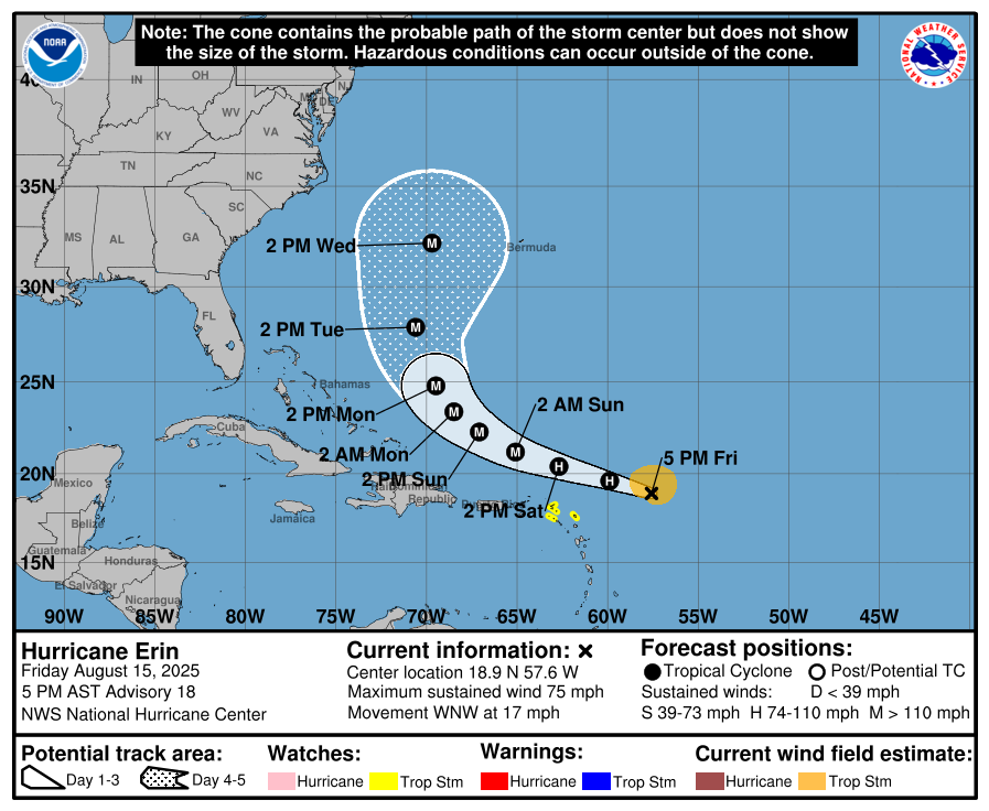
Hurricane Erin is moving west-northwest across the Atlantic and is forecast to rapidly intensify over the weekend, potentially reaching major hurricane strength as it passes near or just north of the northern Leeward Islands on Saturday.
As of 5:00 PM AST today, the National Hurricane Center placed Erin about 365 miles (585 km) east of the northern Leeward Islands, with maximum sustained winds of 75 mph (120 km/h). The storm is moving at 17 mph (28 km/h) on a west-northwest track, with some slowdown expected in the coming days.
A Tropical Storm Watch is in effect for Anguilla and Barbuda, St. Martin and St. Barthelemy, Saba and St. Eustatius, and Sint Maarten. The watch means tropical storm conditions are possible in these areas within the next 48 hours.
Forecasters warn that Erin’s outer bands will begin affecting the northern Leeward Islands tonight, bringing periods of heavy rainfall through Sunday. Rainfall totals are expected to reach 2 to 4 inches in some areas, with isolated amounts up to 6 inches. This could lead to flash flooding, urban flooding, and, in mountainous areas, landslides or mudslides.
Tropical storm conditions could develop in the watch areas as early as Saturday. Hurricane-force winds currently extend up to 25 miles (35 km) from Erin’s centre, while tropical-storm-force winds reach up to 115 miles (185 km), mainly to the north.
Swells generated by Erin are expected to reach the northern Leeward Islands, Virgin Islands, and Puerto Rico this weekend, creating dangerous surf and rip current conditions.
The National Hurricane Center advises residents in the northern Leeward Islands, Virgin Islands, Puerto Rico, the Turks and Caicos, and the southeastern Bahamas to closely monitor Erin’s progress.
NOAA and Air Force Reserve Hurricane Hunter aircraft are scheduled to investigate the storm this evening, which will help refine forecasts.
Discover more from Discover Montserrat
Subscribe to get the latest posts sent to your email.